3D Scanning & Mobile Mapping Services in Oman: Benefits, Applications & Cost Guide (2026)

If you’re searching for 3D scanning or mobile mapping services in Oman, you’re likely looking for faster, more accurate, and productive ways to capture site data and improve project outcomes.

Across Muscat, Sohar, Duqm, and Salalah, industries are rapidly adopting 3D laser scanning in Oman and mobile mapping solutions to replace traditional surveying methods. The result? Better accuracy, faster timelines, and more informed decision-making.

This guide explains everything you need to know—benefits, real-world applications, and the cost of 3D scanning in Oman (2026)—in a clear, practical way.

What Are 3D Scanning & Mobile Mapping Services?

At its core:

  • 3D laser scanning in Oman uses LiDAR technology to capture millions of precise measurements and create detailed digital models (point clouds).
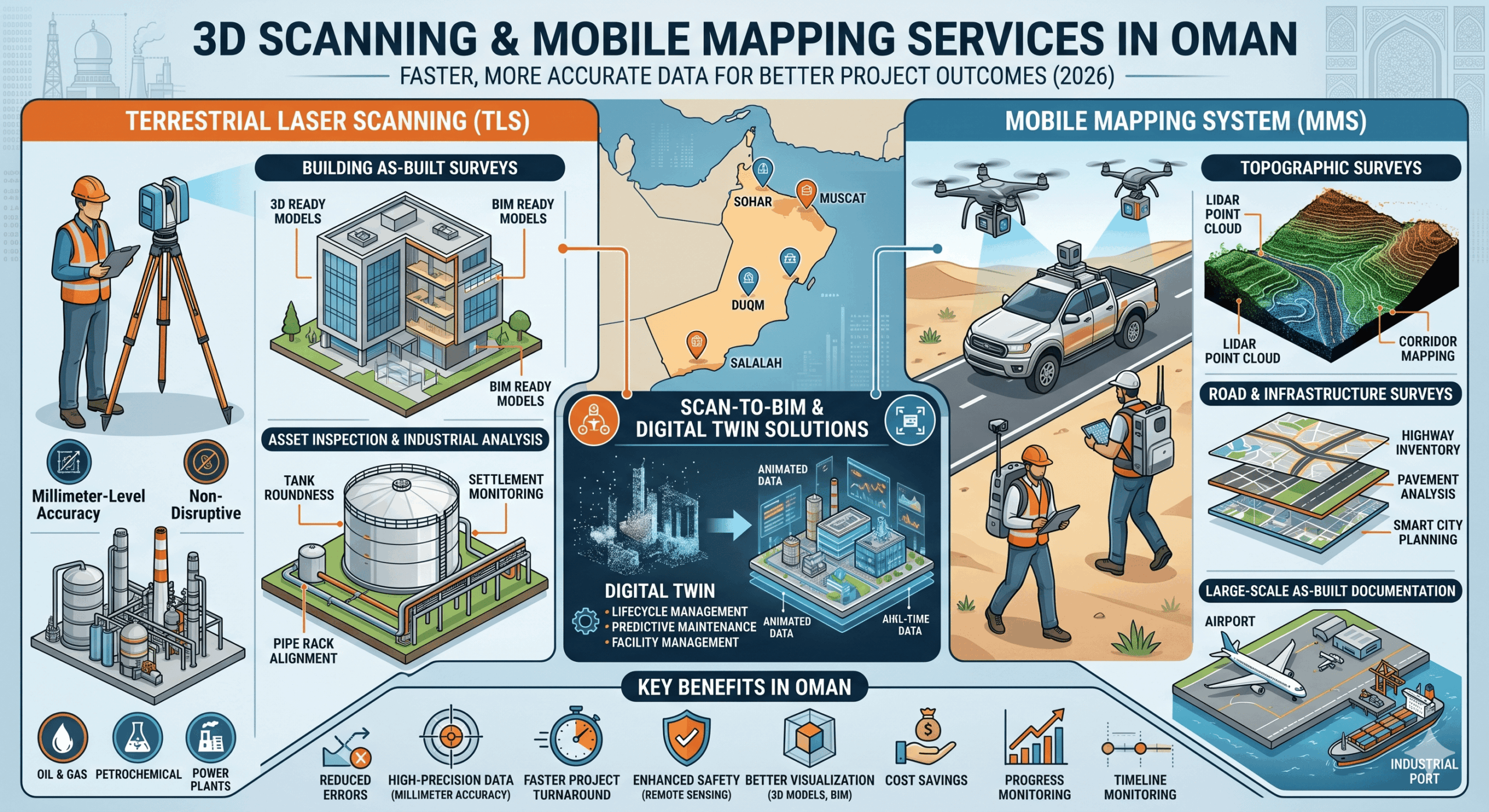
  • Terrestrial laser scanning (TLS) is commonly used for high-accuracy building documentation, industrial asset inspections, and detailed as-built surveys.
  • Mobile mapping services in Oman collect geospatial data while moving—using vehicles, backpacks, or drones—making them ideal for roads, corridors, pipelines, and large infrastructure projects.

Together, these technologies power modern digital surveying and geospatial services in Oman.

Terrestrial Laser Scanning (TLS) Applications in Oman

Building As-Built Surveys

Terrestrial 3D laser scanning is widely used to create accurate as-built documentation for:

  • Commercial buildings
  • Industrial plants
  • Warehouses
  • Residential developments
  • Airports and infrastructure facilities

The captured point cloud data enables engineers and architects to generate:

  • CAD drawings
  • Floor plans
  • Elevations and sections
  • BIM-ready models

This is especially useful for renovation, retrofit, and facility management projects.

Asset Inspection & Industrial Analysis

Terrestrial scanning is highly effective for industrial inspection and deformation analysis, including:

  • Storage tank roundness analysis
  • Tank settlement monitoring
  • Structural deformation checks
  • Pipe rack alignment verification
  • Steel structure inspection
  • Verticality and flatness assessment

Using millimeter-level accuracy, engineers can detect deviations and structural movement without shutting down operations.

Industries benefiting include:

  • Oil & gas
  • Petrochemical plants
  • Power generation facilities
  • Manufacturing plants
  • Ports and marine infrastructure

Mobile Mapping System (MMS) Applications in Oman

Topographic Surveys

Mobile mapping systems allow rapid collection of dense geospatial data for:

  • Topographic mapping
  • Terrain modeling
  • Corridor mapping
  • Utility mapping
  • Urban planning projects

Compared to conventional surveying, MMS significantly reduces field time while capturing more comprehensive data.

Road & Infrastructure Surveys

Mobile mapping is ideal for:

  • Highway surveys
  • Road inventory mapping
  • Pavement analysis
  • Transportation corridor documentation
  • Smart city planning
  • Rail and utility corridor surveys

Vehicle-mounted LiDAR systems can scan kilometers of infrastructure in a single day with high positional accuracy.

As-Built Documentation

Mobile mapping systems are increasingly used for large-scale as-built surveys where speed and coverage are essential, including:

  • Industrial facilities
  • Road corridors
  • Ports
  • Airport infrastructure
  • Pipeline networks

The collected data can be integrated directly into GIS, CAD, and BIM workflows.

Scan-to-BIM & Digital Twin Solutions in Oman

One of the fastest-growing applications in Oman is Scan-to-BIM and digital twin development.

By combining:

  • Terrestrial 3D laser scanning for detailed stationary capture
  • Mobile mapping systems for large-area coverage

Organizations can create highly accurate digital twins of buildings, industrial facilities, and infrastructure assets.

What Is a Digital Twin?

A digital twin is a data-rich virtual replica of a physical asset or environment that enables:

  • Real-time asset visualization
  • Lifecycle management
  • Predictive maintenance
  • Facility management
  • Design validation
  • Infrastructure planning

The integration of TLS and MMS creates a complete digital environment with both precision and scalability.

Why Demand for 3D Scanning in Oman Is Growing

Oman’s infrastructure and industrial sectors are expanding quickly, increasing the need for accurate and efficient surveying solutions.

Key Drivers:

  • Large-scale construction and smart city projects
  • Growth in oil & gas and industrial facilities
  • Infrastructure development across regions
  • Increased demand for as-built documentation in Oman
  • Growing adoption of Scan-to-BIM workflows
  • Rising interest in digital twin technology for asset management

Traditional surveying methods are often slower and less detailed—making 3D scanning and mobile mapping in Oman the preferred alternative.

Key Benefits of 3D Scanning & Mobile Mapping in Oman

1. High-Precision Data (Millimeter-Level Accuracy)

With 3D laser scanning services in Oman, you get highly accurate measurements that are critical for:

  • Engineering
  • Construction
  • Industrial inspection
  • Asset management
  • BIM workflows

2. Faster Project Turnaround

Mobile mapping systems in Oman allow rapid data collection over large areas—reducing survey time from weeks to hours.

3. Enhanced Safety

Using remote scanning technology, teams can avoid hazardous environments such as:

  • Oil & gas facilities
  • High-rise structures
  • Confined industrial spaces
  • Active construction sites
  • Elevated tank roofs and restricted-access areas

4. Better Visualization with 3D Models

3D modeling and BIM integration in Oman allow teams to:

  • Visualize projects before execution
  • Identify clashes early
  • Improve collaboration
  • Enhance decision-making

5. Cost Savings Over Time

While the upfront 3D scanning cost in Oman may vary, it helps reduce:

  • Rework
  • Site errors
  • Project delays
  • Unexpected clashes
  • Operational downtime

6. Progress Monitoring & Design Validation

3D scanning supports:

  • Construction progress tracking
  • Design inspections
  • Design vs. as-built comparison
  • Accurate project documentation
  • Structural monitoring and deformation analysis

Applications of 3D Scanning & Mobile Mapping Services in Oman

Construction & Infrastructure

  • Construction 3D scanning Oman for site documentation
  • Progress monitoring and as-built surveys
  • BIM modeling and clash detection
  • Scan-to-BIM workflows
  • Digital twin creation

Oil & Gas Industry

  • Oil & gas 3D scanning Oman for asset inspection
  • Pipeline mapping and monitoring
  • Facility digitization
  • Tank settlement and roundness analysis
  • Brownfield documentation

Road & Transportation Projects

  • Mobile mapping for roads in Oman
  • Highway and corridor mapping
  • Traffic and infrastructure planning
  • Topographic surveys
  • Asset inventory mapping

Real Estate & Architecture

  • Property modeling and visualization
  • Renovation and retrofit planning
  • Space optimization
  • Existing building documentation

Mining & Industrial Projects

  • Volume calculations
  • Site mapping
  • Equipment and asset tracking
  • Deformation analysis
  • Plant digitization

Heritage & Cultural Preservation

Using 3D laser scanning in Oman, historical sites and landmarks can be digitally preserved for:

  • Restoration planning
  • Documentation
  • Scan-to-Mesh generation
  • Heritage BIM development
  • Digital archiving

Cost of 3D Scanning Services in Oman (2026)

If you’re researching 3D scanning cost in Oman, it’s important to understand what affects pricing.

Key Cost Factors:

  • Size and complexity of the project
  • Required level of detail (LOD)
  • Equipment used (LiDAR, terrestrial scanners, mobile mapping systems)
  • Site accessibility
  • Data processing and deliverables
  • BIM or digital twin requirements

Indicative Pricing Insight:

  • Small projects → Lower cost, faster delivery
  • Large infrastructure or industrial projects → Higher cost due to scale and processing complexity

For the best value, choose a provider that offers both accurate data capture and advanced processing services in Oman.

How to Choose the Best 3D Scanning Company in Oman

When selecting a 3D scanning company in Oman, focus on:

  • Proven experience in Oman-based projects
  • Advanced LiDAR and mobile mapping technology
  • Expertise in terrestrial laser scanning and MMS integration
  • Clear deliverables (point clouds, CAD drawings, BIM models, digital twins)
  • Strong GIS and Scan-to-BIM capabilities
  • Compliance with local regulations and safety standards

A reliable provider of 3D scanning and mobile mapping services in Oman will help you turn raw data into actionable insights.

Common Mistakes to Avoid

When hiring 3D scanning services in Oman, avoid:

  • Choosing based only on low cost
  • Not confirming deliverables upfront
  • Hiring inexperienced providers
  • Ignoring post-processing capabilities
  • Overlooking BIM or digital twin integration requirements

These can significantly impact project quality and timelines.

Final Thoughts

As industries evolve, 3D scanning and mobile mapping services in Oman are becoming essential—not optional.

Whether you’re working on construction, oil & gas, infrastructure, transportation, or industrial facilities, these technologies help you:

  • Improve accuracy
  • Save time
  • Reduce risks
  • Enhance safety
  • Create digital twins
  • Make better operational decisions

By combining terrestrial 3D laser scanning with mobile mapping systems, organizations can achieve complete site digitization—from detailed asset inspection to large-scale topographic mapping and BIM integration.

Choosing the right 3D scanning service provider in Oman ensures you get maximum value from your investment.

FAQs: 3D Scanning & Mobile Mapping Services in Oman

1. What are terrestrial 3D laser scanning services used for?

Terrestrial laser scanning is used for:

  • Building as-built surveys
  • Asset inspection
  • Tank roundness analysis
  • Settlement monitoring
  • Structural deformation analysis
  • Scan-to-BIM workflows

Best Drone Survey Services in Oman: What to Look for Before Hiring (Complete 2026 Guide)

If you’re searching for drone survey services in Oman, you’re likely to compare providers, prices, and capabilities – and wonder how to choose the right one[cite: 1].

Drone surveying (also known as UAV/Aerial surveying in Oman) has become an essential tool for industries like construction, oil & gas, mining, infrastructure, utilities, and real estate. It offers faster data collection, high accuracy, and better project insights compared to traditional land surveying methods.

The Reality: Not all drone survey companies in Oman deliver the same level of quality. This guide keeps things simple and practical – while helping you make an informed decision that aligns with your project goals.


Why Drone Survey Services in Oman Are in High Demand

With rapid development across Muscat and other regions in Oman, the need for aerial survey services in Oman is growing quickly.

Oman’s terrain – mountains, deserts, mining areas, industrial zones, and coastal regions can make traditional surveys slow and resource-heavy. That’s why many businesses now rely on drone mapping services in Oman.

Key Benefits of Drone Surveying:

  • Faster project turnaround times
  • High-precision data (centimeter-level accuracy)
  • Reduced on-site manpower
  • Improved safety in remote or hazardous areas
  • Cost-effective for large-scale land surveys
  • Faster progress monitoring and reporting
  • Better visualization through 3D models and digital twins

From land surveying in Oman to topographic surveys, BIM modeling, bathymetric mapping, and 3D modeling, drones are helping companies work smarter.


What to Look for in a Drone Survey Company in Oman

1. Licensed Drone Operators in Oman

Before anything else, make sure the company is authorized to operate drones in Oman. A reliable drone survey company in Oman will:

  • Hold valid permits and approvals
  • Follow local aviation regulations
  • Ensure data security and compliance

Hiring an unlicensed operator can lead to legal issues and project delays.

2. Experience with Drone Survey Projects in Oman

Not all UAV survey services in Oman are the same. Look for a company that understands your industry:

  • Construction drone surveys Oman → Site mapping & progress tracking
  • Oil & gas drone inspection Oman → Pipeline monitoring & thermal inspections
  • Mining survey Oman → Stockpile volume calculations & terrain mapping
  • Agriculture drone survey Oman → Crop health & multispectral analysis
  • Road and infrastructure drone surveys Oman → Corridor mapping & progress monitoring
  • City development drone surveys Oman → Urban planning & GIS mapping
  • Land development drone surveys Oman → Site planning & grading analysis
  • Coastal and marine drone surveys Oman → Bathymetric and shoreline mapping
  • Solar farm inspection Oman → Thermal imaging and panel inspection

Ask for real project examples—it’s the easiest way to judge their capability.

3. Advanced Drone Technology & Aerial Mapping Tools

The best aerial survey companies in Oman invest in modern equipment. Key technologies include:

  • Drone photogrammetry surveys for orthomosaics, contour mapping, and 3D surface models
  • Drone LiDAR surveys for high-accuracy terrain and topographic mapping in difficult terrain
  • BIM modeling and Scan-to-BIM workflows for construction and infrastructure projects
  • 3D modeling and digital twin creation for buildings, mines, and city development
  • Thermal drone inspections using infrared cameras for heat mapping and asset assessment
  • Solar panel inspection with thermal imaging for identifying defective or overheating modules
  • Multispectral drone surveys for crop health, irrigation, and vegetation analysis
  • Drone videography and aerial imaging for construction progress monitoring and documentation
  • Drone magnetic surveys for detecting metallic targets and subsurface anomalies
  • Bathymetric drone surveys for coastal mapping, shoreline analysis, and underwater terrain assessment
  • Corridor mapping surveys for roads, railways, pipelines, and utility infrastructure
  • Drone inspection services for bridges, towers, industrial plants, and infrastructure assets

4. Clear Deliverables

When hiring drone survey services in Muscat or across Oman, always clarify what you’ll receive. A professional provider should offer:

  • High-resolution Orthomosaic maps
  • Topographic plans with contours and spot levels
  • Digital Elevation Models (DEM) / Digital Terrain Models (DTM)
  • Dense point clouds and 3D surface models
  • BIM-ready models and Scan-to-BIM deliverables
  • CAD and GIS-compatible files
  • As-built plans and engineering drawings
  • Cross-sections and longitudinal profiles
  • Volumetric calculations for cut-and-fill analysis
  • Bathymetric survey data and underwater contour maps
  • Thermal inspection reports and heat maps
  • Multispectral vegetation health reports
  • Magnetic anomaly detection reports
  • Progress monitoring reports with drone imagery and videos
  • Inspection reports and project documentation

If deliverables aren’t clearly defined, expect confusion later.

5. Turnaround Time for Drone Surveys in Oman

One of the biggest advantages of drone surveying in Oman is speed—but timelines still vary. Typical turnaround:

  • Small projects → 1–2 days
  • Medium-scale projects → 3–5 days
  • Large-scale surveys → Several days (including processing and reporting)

Choose a company that balances speed with accuracy.

6. Safety Standards & Risk Management

Professional drone survey companies in Oman take safety seriously. They should have:

  • Certified drone pilots
  • Flight planning procedures
  • Risk assessments
  • Insurance coverage
  • Emergency response procedures
  • Data backup and cybersecurity protocols

This ensures smooth and secure project execution.

7. Cost of Drone Survey Services in Oman

If you’re comparing drone survey cost in Oman, remember—cheapest isn’t always best. Pricing depends on:

  • Project size
  • Terrain complexity
  • Technology used (LiDAR, thermal, multispectral, bathymetric, etc.)
  • Deliverables required
  • Processing and reporting requirements

Instead of focusing only on price, look at overall value: accuracy, expertise, technology, and reliability.

8. Data Processing & GIS Capabilities

Top drone mapping companies in Oman don’t just collect data—they turn it into actionable insights. Look for:

  • GIS data integration and geospatial analysis
  • Point cloud processing and classification
  • Coordinate system and georeferencing capabilities
  • Spatial data processing and feature extraction
  • CAD / BIM / GIS-compatible output formats
  • Terrain analysis and surface modeling
  • Digital twin and 3D visualization capabilities
  • Centralized data management and visualization tools
  • Cloud-based project sharing and collaboration platforms

This is what makes drone surveys truly valuable.


Industries Using Drone Survey Services in Oman

Drone technology is widely used across:

  • Construction surveying Oman – Planning and monitoring
  • Oil & gas drone services Oman – Inspection and maintenance
  • Mining and quarry surveys Oman – Volume tracking and terrain analysis
  • Agriculture drone mapping Oman – Crop and irrigation analysis
  • Real estate & land survey Oman – Property development
  • Infrastructure and road projects Oman – Corridor mapping and progress tracking
  • Coastal and marine projects Oman – Bathymetric and shoreline surveys
  • Renewable energy projects Oman – Solar panel thermal inspections
  • Smart city and urban planning Oman – GIS and 3D city modeling

If your project involves land, infrastructure, utilities, or industrial assets, UAV survey services in Oman can significantly improve efficiency.


Common Mistakes to Avoid When Hiring Drone Survey Services

When choosing a drone survey provider in Oman, avoid:

  • Hiring unlicensed operators
  • Ignoring past project experience
  • Choosing outdated technology
  • Not confirming deliverables
  • Falling for very low pricing
  • Overlooking data processing capabilities
  • Ignoring safety and compliance standards

These mistakes can lead to inaccurate data and costly rework.


Final Thoughts: Choosing the Right Drone Survey Service in Oman

Finding the right drone survey company in Oman isn’t just about ticking boxes—it’s about making sure your project runs smoothly from start to finish.

A reliable provider will help you:

  • Save time and costs
  • Improve accuracy
  • Reduce risks
  • Enhance project visualization and monitoring
  • Make better project decisions

Take the time to compare options, ask questions, and choose a partner—not just a service.


FAQs: Drone Survey Services in Oman

1. What are drone survey services in Oman?

Drone survey services use UAVs to capture aerial data for mapping, inspections, monitoring, and analysis across industries like construction, oil & gas, mining, infrastructure, and agriculture in Oman.

2. Are drone surveys legal in Oman?

Yes, drone surveys are legal, but operators must have proper permits and follow local aviation regulations.

3. How much do drone survey services cost in Oman?

The cost of drone survey services in Oman depends on project size, terrain, technology used, and required deliverables. It’s best to request a customized quote.

4. How accurate is drone surveying in Oman?

Modern UAV surveys in Oman can achieve centimeter-level accuracy using RTK GPS, PPK workflows, photogrammetry, and LiDAR technology.

5. Which industries use drone survey services in Oman?

Construction, oil & gas, mining, infrastructure, agriculture, renewable energy, coastal engineering, and real estate are among the main industries using aerial survey services in Oman.

6. What deliverables do drone survey companies provide?

Typical outputs include orthomosaic maps, contour maps, DEM/DTM files, BIM models, thermal reports, bathymetric maps, GIS-ready data, 3D models, and inspection reports.

7. How do I choose the best drone survey company in Oman?

Look for licensing, industry experience, advanced technology, clear deliverables, GIS/BIM capabilities, safety standards, competitive pricing, and strong client reviews.

By focusing on these factors, you’ll be able to confidently choose the best drone survey services in Oman—and ensure your project is backed by accurate, reliable, and actionable data.

Scroll to top