If you’re searching for 3D scanning or mobile mapping services in Oman, you’re likely looking for faster, more accurate, and productive ways to capture site data and improve project outcomes.
Across Muscat, Sohar, Duqm, and Salalah, industries are rapidly adopting 3D laser scanning in Oman and mobile mapping solutions to replace traditional surveying methods. The result? Better accuracy, faster timelines, and more informed decision-making.
This guide explains everything you need to know—benefits, real-world applications, and the cost of 3D scanning in Oman (2026)—in a clear, practical way.
What Are 3D Scanning & Mobile Mapping Services?
At its core:
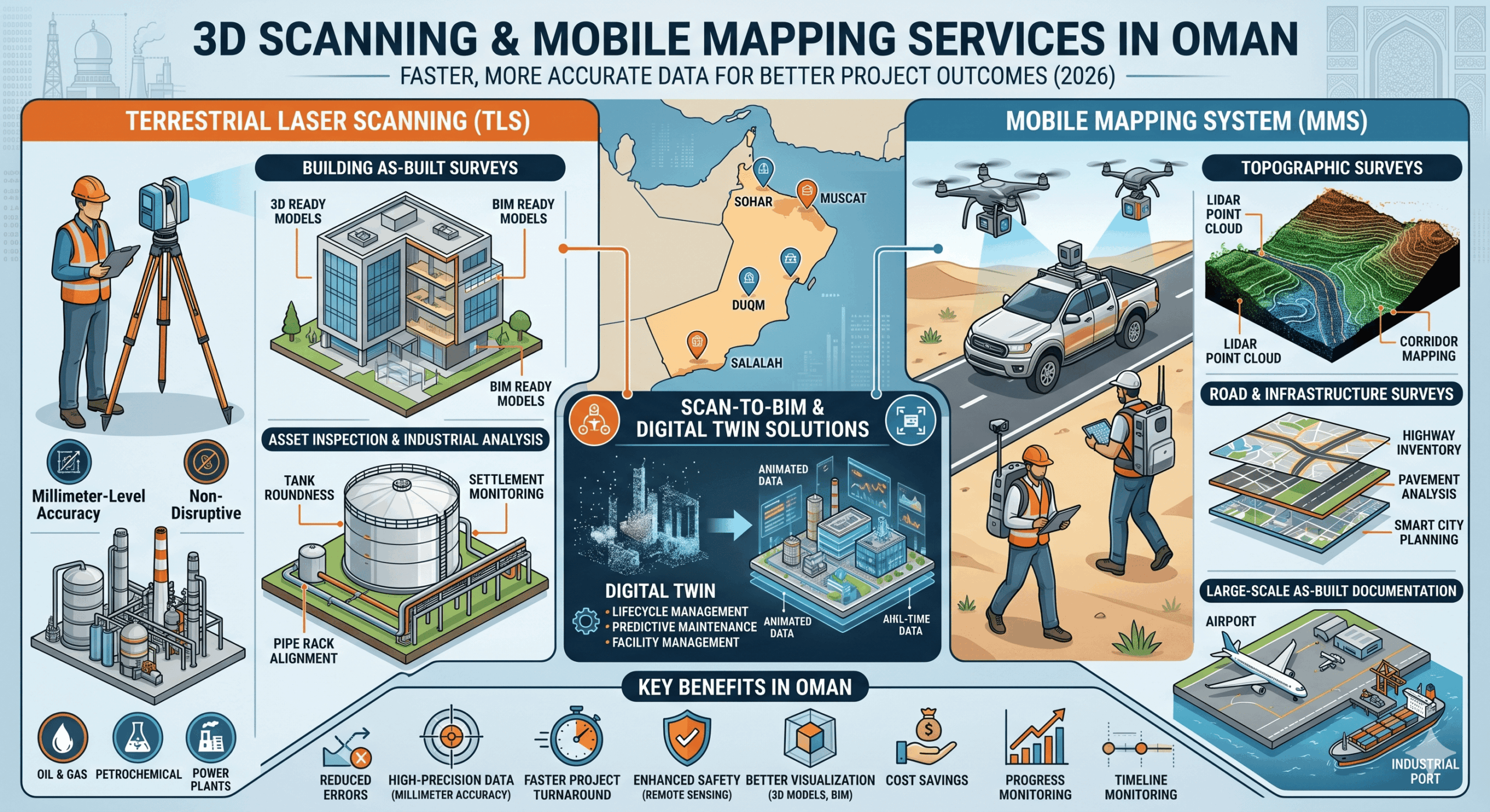
- 3D laser scanning in Oman uses LiDAR technology to capture millions of precise measurements and create detailed digital models (point clouds).
- Terrestrial laser scanning (TLS) is commonly used for high-accuracy building documentation, industrial asset inspections, and detailed as-built surveys.
- Mobile mapping services in Oman collect geospatial data while moving—using vehicles, backpacks, or drones—making them ideal for roads, corridors, pipelines, and large infrastructure projects.
Together, these technologies power modern digital surveying and geospatial services in Oman.
Terrestrial Laser Scanning (TLS) Applications in Oman
Building As-Built Surveys
Terrestrial 3D laser scanning is widely used to create accurate as-built documentation for:
- Commercial buildings
- Industrial plants
- Warehouses
- Residential developments
- Airports and infrastructure facilities
The captured point cloud data enables engineers and architects to generate:
- CAD drawings
- Floor plans
- Elevations and sections
- BIM-ready models
This is especially useful for renovation, retrofit, and facility management projects.
Asset Inspection & Industrial Analysis
Terrestrial scanning is highly effective for industrial inspection and deformation analysis, including:
- Storage tank roundness analysis
- Tank settlement monitoring
- Structural deformation checks
- Pipe rack alignment verification
- Steel structure inspection
- Verticality and flatness assessment
Using millimeter-level accuracy, engineers can detect deviations and structural movement without shutting down operations.
Industries benefiting include:
- Oil & gas
- Petrochemical plants
- Power generation facilities
- Manufacturing plants
- Ports and marine infrastructure
Mobile Mapping System (MMS) Applications in Oman
Topographic Surveys
Mobile mapping systems allow rapid collection of dense geospatial data for:
- Topographic mapping
- Terrain modeling
- Corridor mapping
- Utility mapping
- Urban planning projects
Compared to conventional surveying, MMS significantly reduces field time while capturing more comprehensive data.
Road & Infrastructure Surveys
Mobile mapping is ideal for:
- Highway surveys
- Road inventory mapping
- Pavement analysis
- Transportation corridor documentation
- Smart city planning
- Rail and utility corridor surveys
Vehicle-mounted LiDAR systems can scan kilometers of infrastructure in a single day with high positional accuracy.
As-Built Documentation
Mobile mapping systems are increasingly used for large-scale as-built surveys where speed and coverage are essential, including:
- Industrial facilities
- Road corridors
- Ports
- Airport infrastructure
- Pipeline networks
The collected data can be integrated directly into GIS, CAD, and BIM workflows.
Scan-to-BIM & Digital Twin Solutions in Oman
One of the fastest-growing applications in Oman is Scan-to-BIM and digital twin development.
By combining:
- Terrestrial 3D laser scanning for detailed stationary capture
- Mobile mapping systems for large-area coverage
Organizations can create highly accurate digital twins of buildings, industrial facilities, and infrastructure assets.
What Is a Digital Twin?
A digital twin is a data-rich virtual replica of a physical asset or environment that enables:
- Real-time asset visualization
- Lifecycle management
- Predictive maintenance
- Facility management
- Design validation
- Infrastructure planning
The integration of TLS and MMS creates a complete digital environment with both precision and scalability.
Why Demand for 3D Scanning in Oman Is Growing
Oman’s infrastructure and industrial sectors are expanding quickly, increasing the need for accurate and efficient surveying solutions.
Key Drivers:
- Large-scale construction and smart city projects
- Growth in oil & gas and industrial facilities
- Infrastructure development across regions
- Increased demand for as-built documentation in Oman
- Growing adoption of Scan-to-BIM workflows
- Rising interest in digital twin technology for asset management
Traditional surveying methods are often slower and less detailed—making 3D scanning and mobile mapping in Oman the preferred alternative.
Key Benefits of 3D Scanning & Mobile Mapping in Oman
1. High-Precision Data (Millimeter-Level Accuracy)
With 3D laser scanning services in Oman, you get highly accurate measurements that are critical for:
- Engineering
- Construction
- Industrial inspection
- Asset management
- BIM workflows
2. Faster Project Turnaround
Mobile mapping systems in Oman allow rapid data collection over large areas—reducing survey time from weeks to hours.
3. Enhanced Safety
Using remote scanning technology, teams can avoid hazardous environments such as:
- Oil & gas facilities
- High-rise structures
- Confined industrial spaces
- Active construction sites
- Elevated tank roofs and restricted-access areas
4. Better Visualization with 3D Models
3D modeling and BIM integration in Oman allow teams to:
- Visualize projects before execution
- Identify clashes early
- Improve collaboration
- Enhance decision-making
5. Cost Savings Over Time
While the upfront 3D scanning cost in Oman may vary, it helps reduce:
- Rework
- Site errors
- Project delays
- Unexpected clashes
- Operational downtime
6. Progress Monitoring & Design Validation
3D scanning supports:
- Construction progress tracking
- Design inspections
- Design vs. as-built comparison
- Accurate project documentation
- Structural monitoring and deformation analysis
Applications of 3D Scanning & Mobile Mapping Services in Oman
Construction & Infrastructure
- Construction 3D scanning Oman for site documentation
- Progress monitoring and as-built surveys
- BIM modeling and clash detection
- Scan-to-BIM workflows
- Digital twin creation
Oil & Gas Industry
- Oil & gas 3D scanning Oman for asset inspection
- Pipeline mapping and monitoring
- Facility digitization
- Tank settlement and roundness analysis
- Brownfield documentation
Road & Transportation Projects
- Mobile mapping for roads in Oman
- Highway and corridor mapping
- Traffic and infrastructure planning
- Topographic surveys
- Asset inventory mapping
Real Estate & Architecture
- Property modeling and visualization
- Renovation and retrofit planning
- Space optimization
- Existing building documentation
Mining & Industrial Projects
- Volume calculations
- Site mapping
- Equipment and asset tracking
- Deformation analysis
- Plant digitization
Heritage & Cultural Preservation
Using 3D laser scanning in Oman, historical sites and landmarks can be digitally preserved for:
- Restoration planning
- Documentation
- Scan-to-Mesh generation
- Heritage BIM development
- Digital archiving
Cost of 3D Scanning Services in Oman (2026)
If you’re researching 3D scanning cost in Oman, it’s important to understand what affects pricing.
Key Cost Factors:
- Size and complexity of the project
- Required level of detail (LOD)
- Equipment used (LiDAR, terrestrial scanners, mobile mapping systems)
- Site accessibility
- Data processing and deliverables
- BIM or digital twin requirements
Indicative Pricing Insight:
- Small projects → Lower cost, faster delivery
- Large infrastructure or industrial projects → Higher cost due to scale and processing complexity
For the best value, choose a provider that offers both accurate data capture and advanced processing services in Oman.
How to Choose the Best 3D Scanning Company in Oman
When selecting a 3D scanning company in Oman, focus on:
- Proven experience in Oman-based projects
- Advanced LiDAR and mobile mapping technology
- Expertise in terrestrial laser scanning and MMS integration
- Clear deliverables (point clouds, CAD drawings, BIM models, digital twins)
- Strong GIS and Scan-to-BIM capabilities
- Compliance with local regulations and safety standards
A reliable provider of 3D scanning and mobile mapping services in Oman will help you turn raw data into actionable insights.
Common Mistakes to Avoid
When hiring 3D scanning services in Oman, avoid:
- Choosing based only on low cost
- Not confirming deliverables upfront
- Hiring inexperienced providers
- Ignoring post-processing capabilities
- Overlooking BIM or digital twin integration requirements
These can significantly impact project quality and timelines.
Final Thoughts
As industries evolve, 3D scanning and mobile mapping services in Oman are becoming essential—not optional.
Whether you’re working on construction, oil & gas, infrastructure, transportation, or industrial facilities, these technologies help you:
- Improve accuracy
- Save time
- Reduce risks
- Enhance safety
- Create digital twins
- Make better operational decisions
By combining terrestrial 3D laser scanning with mobile mapping systems, organizations can achieve complete site digitization—from detailed asset inspection to large-scale topographic mapping and BIM integration.
Choosing the right 3D scanning service provider in Oman ensures you get maximum value from your investment.
FAQs: 3D Scanning & Mobile Mapping Services in Oman
1. What are terrestrial 3D laser scanning services used for?
Terrestrial laser scanning is used for:
- Building as-built surveys
- Asset inspection
- Tank roundness analysis
- Settlement monitoring
- Structural deformation analysis
- Scan-to-BIM workflows